



 The Fairfax Girl Team
If it feels like we’ve only had rain on the weekends and during our 9-to-5s, you’re not making it up. According to locally collected data, both August and September 2026 were the rainiest on record in recent history. But there is a silver lining to these literal rain clouds: Northern Virginia is officially downgraded from a drought warning to a drought watch. A late-September report from the Virginia Drought Monitoring Task Force found enough improvement to recommend moving Northern Virginia from a drought warning to a drought watch. And looking a little farther ahead, early winter models highlighted by Capital Weather are leaning toward a wetter-than-normal winter along the East Coast. Read on for the latest Northern Virginia drought update + what early forecasts are saying about winter 2026-2027.
The Drought Situation is Looking Better
After several weeks of rain, Northern Virginia’s drought picture is moving in the right direction. At its September 29th meeting, the Virginia Drought Monitoring Task Force recommended lowering the Northern Virginia and Northern Piedmont regions from a drought warning to a drought watch. Portions of the Shenandoah region were also recommended for a downgrade.
There is some real rain behind that improvement, too. According to the September drought report, large portions of Northern Virginia, Northern Piedmont, and the northern Shenandoah region received between 125% and 150% of normal precipitation during portions of the previous 60- and 90-day periods. Northern Virginia’s water-year precipitation stood at 90.21% of normal as of September 28th, and its regional precipitation indicator had returned to normal status.
Read more: Northern Virginia Haunted Houses + Spooky Attractions to Visit in 2026
The Community Collaborative Rain, Hail + Snow Network (CoCoRaHS) is a project sponsored by National Oceanographic + Atmospheric Administration (NOAA) and the National Science Foundation (NSF). It’s a community network of weather observers who report precipitation at their locations. It’s created a nationwide resource about precipitation over time.


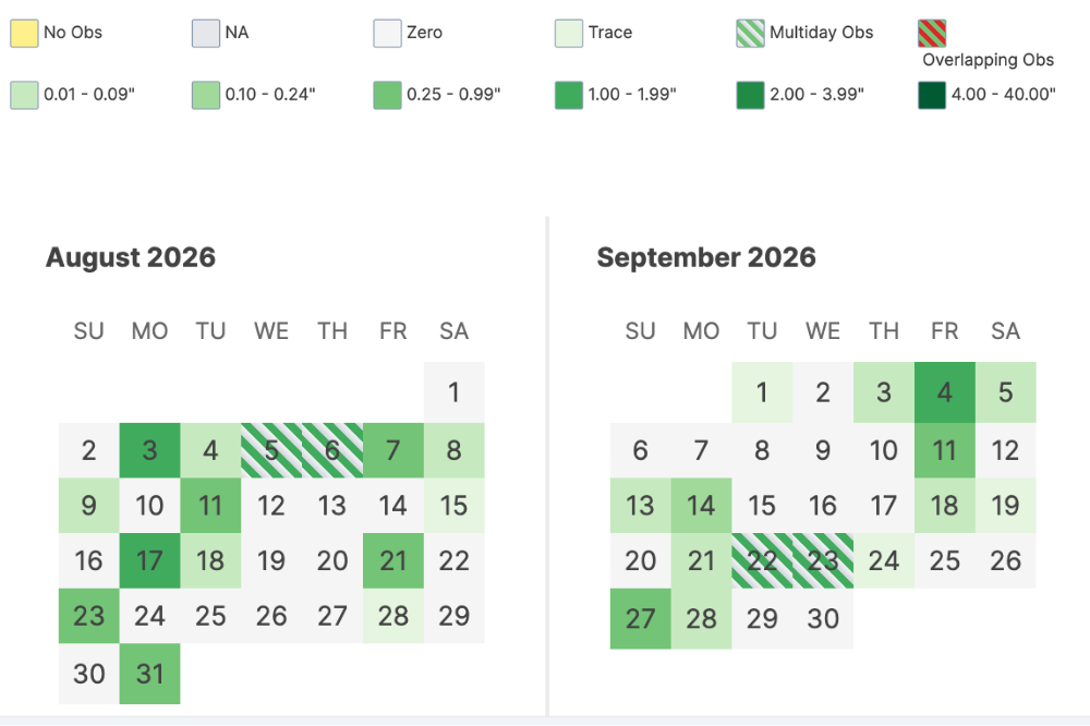 Totally depressing weekend rain graph courtesy of (CoCoRaHS)
The station located in Fairfax bears out our theory that there were far too many rainy weekends in August and September 2026. According to the data, August had 4 out of 8 weekend days with rain, plus 2 Fridays. September had the same, plus 3 rainy Fridays. Those rainy days were part of a larger trend: both August and September 2026 had high amounts of rainfall. August saw 6.16” of rain, and September 4.66”. Per NOAA, the 30-year-average for August is 3.53” and September is 4.16”.
Looking Ahead to Winter
According to an October 5th winter outlook from Capital Weather, seasonal computer models from Canada and Europe are projecting substantially above-normal precipitation along much of the East Coast, including the Washington, D.C. area, for winter 2026-2027.
A historically strong El Niño is one of the big factors behind the wetter signal. El Niño winters can favor increased precipitation in the Mid-Atlantic, which could be helpful this year given the region’s lingering groundwater deficit. The state’s own seasonal drought outlook is also optimistic, favoring additional drought improvement across much of Virginia through the end of 2026.
Capital Weather notes that the same seasonal models forecasting a wet winter generally favor near- to slightly above-normal temperatures across the Mid-Atlantic. December and January currently look warmer relative to normal than February, meaning plenty of precipitation does not automatically translate to plenty of snow.
See more: 15+ Indoor Playgrounds + Play Spaces for Kids in Northern Virginia
The biggest factor is whether cold air happens to be in place when storms arrive. That depends heavily on atmospheric patterns like the polar vortex, which forecasters cannot reliably predict months in advance. Strong El Niño winters have also produced just about every possible outcome around D.C., from blockbuster snowstorms to winters that barely required a snow shovel.
If the current models hold, February could have a better shot at combining moisture + cold air than the earlier part of the winter. Colder locations farther west and at higher elevations, particularly in and around the Appalachians, may also have a better chance of turning the projected extra precipitation into snow.
Follow @thefairfaxgirl on Instagram + TikTok for the latest Northern Virginia updates, and check out our events calendar, which has over 100+ events weekly to peruse. Sign up for our newsletter here.